Keeping the Ladbroke area special
Communal gardens
Introduction
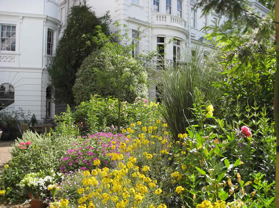
When James Weller Ladbroke decided to develop the agricultural land that constituted his estate, he employed Thomas Allason, a prominent London architect, to draw up a master plan. Allason produced his plan in 1823. It included a huge circus over 500 metres across, centred on the hill on which St John’s Church now stands, with a road running north-south through the middle. Each half of the circus featured a large open garden with houses all around it. As the gardens would be entirely enclosed by the houses, they would be private to the residents.
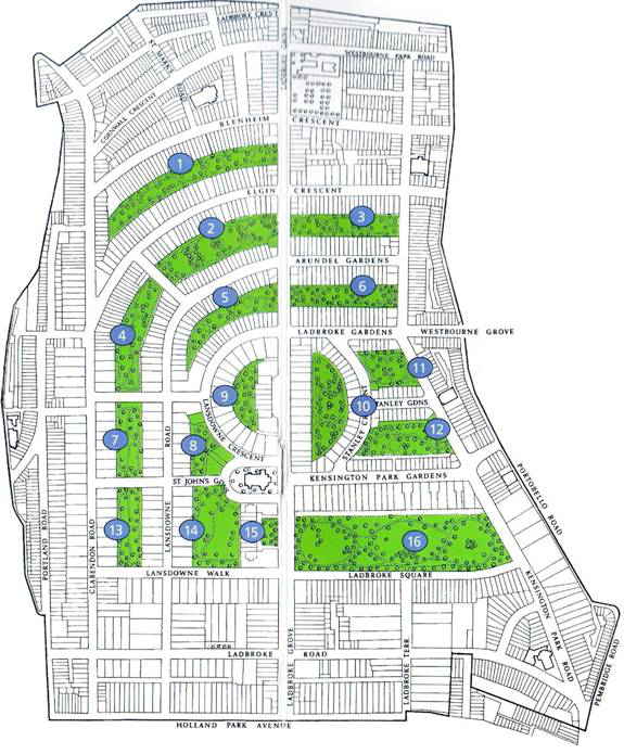
Work started shortly after on the houses on the southernmost part of the estate, along what is now Holland Park Avenue. But construction was brought to an abrupt halt by a financial crisis in 1825, and Allason’s grand plan for communal gardens further up the hill remained unimplemented. Much of the undeveloped land was finally let to a speculator who opened a race-course in 1837. But it was not a great success, and after various crises the race-course closed down in 1842. By this time the building market was reviving, and a new master-plan was drawn up by another architect, James Thomson. Although he radically overhauled the original, he shared Allason’s love of landscaping. His plan retained a central north-south road (Ladbroke Grove) and the main feature of shared gardens with crescents around the hill, albeit in a modified form. What he designed is essentially what we have inherited today, with 16 gardens or garden squares rather than the two enormous semi-circular ones envisaged by Allason. English Heritage has given the ensemble of gardens on the Ladbroke estate a Grade II listing on the Register of Historic Parks and Gardens (click on
http://list.english-heritage.org.uk/resultsingle.aspx?uid=1000242 for the full English Heritage description).
In most of the gardens, the houses backing onto the garden have their own private garden as well, usually separated from the communal garden by a railing with a gate in it. Most gardens also have an entrance on the street for access by contractors etc.
Governance of the gardens
From the beginning, the gardens (originally known as “pleasure grounds” or sometimes “paddocks”) were available only to residents of the houses adjoining them, and the residents were required to contribute to the upkeep. Originally the 19th century developer of the houses round the garden kept ownership of the garden and inserted into the leases of the houses an obligation to pay £2.2s (two guineas) annually to him. Most developers seem, however, to have become fed up with collecting these small amounts and organising the maintenance of the garden, and most of the gardens were conveyed to trustees who decided on an appropriate yearly rent. The trustees did not necessarily have an easy task, especially when it came to the collection of the rents. Fortunately, legislation was passed in 1851 and 1863 which allowed the individual gardens to place themselves within a legislative framework that enabled the Council to collect the rents on their behalf. Today most gardens rely on the Council to collect contributions through a levy or precept that must be paid along with the Council tax by all the households with access to the gardens (which includes those living in flats in blocks adjoining the garden). But all still have committees drawn from the residents that must decide on the levy; on the rules and regulations applying in the garden; and on such matters as planting policy.
PLEASE NOTE THAT THE LADBROKE ASSOCIATION HAS NO DIRECT INVOLVEMENT IN THE RUNNING OF THE GARDENS AND QUESTIONS ABOUT ACCESS ETC. SHOULD BE ADDRESSED TO THE RELEVANT GARDEN COMMITTEE.
Legislation covering the gardens
Different gardens are covered by different legislation. In 1851, the Borough obtained a private Act, the Kensington Improvement Act 1851, which provides that, for the gardens to which it applies:
- those liable to pay Council Tax (originally rates) in respect of any dwelling surrounding the square or garden and who have been resident for at least a year, are members of the garden committee;
- the garden committee can appoint a sub-committee;
- the garden committee or sub-committee is exclusively responsible for the care, management and regulation of the garden;
- certain procedures should be followed for the calling and conduct of meetings of the garden committee and sub-committee;
- the garden committee must elect a chairman who has a casting vote;
- the garden committee and any sub-committee have the power to make byelaws for the proper management of the garden;
- at an annual meeting, the garden committee may determine the amount of money, to be raised via an annual levy as part of the Council Tax, which is necessary to maintain and keep the garden in order; accounts of the previous year’s expenditure must be produced at this meeting;
- the residents of the houses round the square or garden have the right to use it.
The Town Gardens Protection Act 1863 is an alternative that can also be used by garden committees. Text if Act here. It provides that:
- the residents of the dwellings surrounding the garden elect a garden committee annually;
- the garden committee must consist of not more than nine nor fewer than three of the inhabitants of the dwellings surrounding the square who are liable to pay Council Tax;
- the garden committee may, at an annual meeting, determine the amount required for the maintenance or management of the garden to be raised via an annual levy as part of the Council Tax;
- the garden committee has the power to make byelaws for the management and protection of the garden.
There is much further useful information on the Garden Squares section of the RBKC website – see
https://www.rbkc.gov.uk/council-tax/garden-squares
The London Squares Preservation Act 1931 also gives protection to the gardens of the Ladbroke estate. Section 3 of the Act lays down that their use shall be restricted to ‘ornamental pleasure grounds or grounds for play, rest and recreation’, and the only buildings and structures allowed are those which are ‘necessary or convenient for, and in connection with, the use and maintenance of such squares’. It puts a duty on the Council to enforce this provision. The Act also contains a number of detailed provisions on works affecting the gardens and related matters. Full text of Act here.
The Act was used recently by the Council to prevent encroachment into a communal garden in the Courtfield Gardens area. The owner of a property that gives onto Courtfield Gardens West wanted to dig a 3.5 metres deep lightwell projecting into the garden. A deed was in existence, made in the 1960s, that gave the owner of that property a legal right to carry out the excavation, and the owner made a successful application for planning permission in 2012. The applicant was however warned that consent might also be needed under the 1931 Act, a consent which it is also for the Council to give. The developers went ahead without seeking such consent. The Council warned them the development was in breach of the Act. The developers then put in an application for the requisite consent. The Council refused to give consent on the grounds that, whereas the Act specifically provides for Council to authorise underground works, there is nothing in the Act that allowed them to give consent to the construction of an open lightwell.
The developers sought judicial review of the Council’s decision and the High Court delivered its judgement in February 2015 [R (Eliterank) v the Royal Borough of Kensington & Chelsea [2015] EWHC 220 (Admin)]. The Court found for the Council. It made clear that the term “underground” in the Act means completely underground (underground car-parks have for instance been authorised under some garden squares); and that Councils have no powers to authorise works that are not completely underground, which remain illegal under the Act.
This is an important case, as it is thought to be the first one taken under the 1931 Act. The High Court decision effectively confirmed that this somewhat obscure piece of legislation is still valid and that Councils can take enforcement action against people who encroach onto garden squares in breach of the Act.
Grade II status of the Gardens and planning regime
In 1987, English Heritage (now Historic England) registered the sixteen gardens of the Ladbroke estate as Grade II on the Register of Parks and Gardens of Special Historic Interest. There is information about the Register on the Historic England website at
https://historicengland.org.uk/listing/what-is-designation/registered-parks-and-gardens/.
The inclusion of a historic park or garden on the Register in itself brings no additional statutory controls. However, local authorities are required by central government to make provision for the protection of the historic environment in their policies and in the allocation of resources. The fact that a garden has been registered is also a “material planning consideration”, so when deciding planning applications affecting a communal garden the Council should take into account the historic interest of the site. They must also consult The Gardens Trust (see www.thegardenstrust.org) on all applications affecting registered sites. In London, The Gardens Trust delegates its role in relation to planning applications to the London Parks and Gardens Trust (see http://www.londongardenstrust.org).
Quite a few of the Council’s stated planning policies are also relevant to the communal gardens and to the buildings in them or backing onto them.
Click here for more information.
Many of the houses backing onto the gardens are listed, or subject to Article 4 Directions meaning that planning permission is needed for any alterations to the backs of the houses and/or the walls, railings and fences facing the communal gardens. See under the individual gardens below for details.
Individual gardens
The numbers correspond to those on the map opposite.
The names of the gardens are those given to them by the relevant garden committee. The descriptions have mainly been taken from English Heritage. Brief details are also given of planning restrictions on the backs of houses bordering the gardens.
7. Clarendon and Lansdowne Garden
13. Lansdowne Road and Clarendon Road Garden
14. Hanover Garden
Arundel Elgin Garden (3)
This communal garden lies behind the houses on the north side of Arundel Gardens (Nos. 6-50 evens) and behind those on the south side of the stretch of Elgin Crescent between Ladbroke Road and Kensington Park Road (Nos. 17-61 odds). It extends over 0.53 hectares. The houses have small private gardens leading to a broad, level communal garden, dominated by a huge plane in the centre. An oval enclosure, surrounded by a privet hedge, is flanked by lawns backed by beds with flowering shrubs. The complex mid-19thcentury path layout has been simplified and some of the original internal railings survive.
The garden is constituted under the Town Gardens Protection Act 1863. There are Article 4 directions removing permitted development rights in respect of:
- enlargements or alterations affecting the rear of the houses, applying to Nos. 10-44 Arundel Gardens and 17-59 Elgin Crescent;
- alterations to walls, gates and fences facing the communal gardens, applying to nos. 8-44 Arundel Gardens.
Its website is: www.arundelandelgingardens.org
Contact: info@arundelandelgingardens.org
Click here for the by-laws.
Arundel Ladbroke Garden (6)
This 0.49 hectare communal garden lies between the south side of Arundel Gardens (nos. 1-47 odds) and the north side of Ladbroke Gardens (Nos. 1-23 consec). Private gardens lead onto the steeply sloping communal garden, planted with 19th century planes and other large trees including a catalpa, horse chestnut, and two Turkey oaks; and underplanted by small flowering trees and woodland shrubs. The mid 19th century path layout, some of the original internal railings, and eleven large plane trees survive.
The garden is constituted under the Kensington Improvement Act 1851. There are Article 4 directions removing permitted development rights in respect of:
- alterations to the rear of the houses in respect of Nos. 15-21 Ladbroke Gardens;
- enlargements or alterations affecting the rear of the house in respect of Nos. 5-41 odds Arundel Gardens
- alterations to walls, gates and fences facing the communal gardens of Nos. 15-21 and 23 Ladbroke Gardens;
- erection, alteration or demolition of walls facing the communal gardens in respect of Nos. 1 and 5-47 odds Arundel Gardens.
Its website is: www.arundelladbrokegardens.co.uk
Contact: https://www.arundelladbrokegardens.co.uk/contact
Between Portobello Road and Kensington Park Road (Nos. 35-41 odds and 54-62 evens)
This was the sliver of land that belonged to Thomas Pocock, and he seems to have organised the building of these two handsome terraces himself rather than giving building leases. They were completed in 1850-51 and both were originally named Kensington Park Terrace.
The photograph on the left shows 54 Chepstow Villas, on the corner of Portobello Road, part of the handsome terrace on the north side between Portobello Road and Kensington Park Road. (photo © Thomas Erskine 2006)
Blenheim-Elgin Garden (1)
This garden lies behind the south side (Nos. 53-137 odds) of Blenheim Crescent and the north side (50-120 evens) of Elgin Crescent, with Ladbroke Grove to the east and Clarendon Road to the west. It extends over 0.81 ha. Large private gardens lead from the terraced houses onto a long communal garden, with a path layout much simplified from its original pattern. There is a hard games court at the east end, screened by evergreen shrubs, and the rest of the garden is largely open with scattered mature trees. The original street railings survive along Ladbroke Grove. A good informal history of the garden has been written by Catherine Thompson-McCausland.
The garden is constituted under the Town Gardens Protection Act 1863. There are Article 4 Directions removing permitted development rights in respect of:
- alterations to the rear of the house for Nos. 55-135 (odds) Blenheim Crescent and 54-120 (evens) of Elgin Crescent.
Contact: secretary@blenheimelgin.com
Its website is: www.blenheimelgin.com
Clarendon and Lansdowne Garden (7)
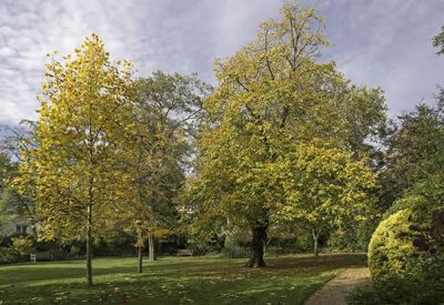
Lansdowne and Clarendon Garden in autumn 2015.
Photo: Andrew Wilson
This 0.41 hectare communal garden is one of the earliest gardens in the estate and was laid out in around 1860. It lies between Nos. 44-58 (evens) Clarendon Road to the west and Nos. 29-43 (odds) Lansdowne Road to the east. It abuts onto St John’s Gardens to the south and Lansdowne Rise to the north. It is about an acre in size and it slopes slightly towards Clarendon Road. The garden slopes gently to the west and is backed to the west and east by private gardens with original internal railings. Most of the garden is open with scattered mature trees, and is bounded by a perimeter path and shrub beds. A grove of birch trees stands in the centre of the gardens, replacing a central shrub bed which was originally connected to the perimeter path by cross paths.
The houses on the Lansdowne Road side are Grade II listed. There are Article 4 directions removing permitted development rights in respect of:
- alterations to walls, gates and fences facing the communal gardens for all the Clarendon Road houses on the garden.
Hanover Gardens (14)
This communal garden of 0.78 hectares (1.9 acres) used to be known as Hanover Terrace Garden, Hanover Terrace being the old name of Lansdowne Walk. It is bounded by buildings on two sides, with tall terraced houses along Ladbroke Grove (Nos. 41-57 odds) to the east, and semi-detached villas with infills along Lansdowne Road (Nos. 16-30 evens) to the west. On the Ladbroke Grove side, there are small private gardens, with larger ones on the Lansdowne Road side. The houses in Lansdowne Walk facing the gardens also have access.
The sloping garden is one of the earliest on the estate, with views to the spire of St John’s church between shrub beds, scattered mature trees and clumps. The original path layout survives, with a straight terraced path along the east side and a meandering path across the centre. The internal mid-19th century railings survive along the Lansdowne Road side. A bench marks the 90th birthday of the landscape architect, Dame Sylvia Crowe, a former resident. There are two street entrances into the gardens in Lansdowne Walk.
The Local Studies section of Kensington Public Library contains an 1845 document whereby James Weller Ladbroke, the then owner of the Ladbroke estate, granted a 95-year lease to the developer Richard Roy of No. 1 Lansdowne Terrace (now 16 Lansdowne Road) and “the adjoining pleasure ground” at £15 a year (deed 4600).
There are Article 4 Directions removing permitted development rights in respect of:
- alterations to the rear of the house for Nos. 16-26 Lansdowne Road.
Contact: Stephanie Gibbs, Hon Sec hanovergardens1@gmail.com
Ladbroke Grove Garden (15)
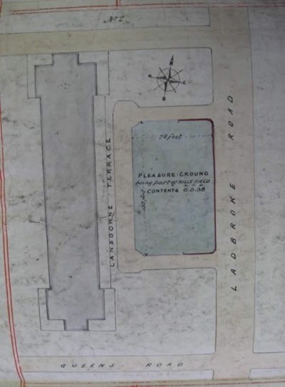
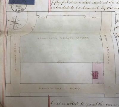
Plan from early lease.
This 0.1 hectare (or quarter-acre) garden lies along Ladbroke Grove just south of St John’s church, in front of Nos.39-65 Ladbroke Grove. The small rectangular garden of grass and trees is unenclosed except for a low brick wall. It is constituted under the Town Gardens Protection Act 1863.
There are deeds in the Local Studies Centre recording how James Weller Ladbroke, the then owner of the Ladbroke estate, gave a 99-year lease for £15 a year of the plot of land for this garden to the developer Richard Roy in 1845, and J.W. Ladbroke’s heir, Felix Ladbroke, subsequently (in 1862) conveyed the freehold to Roy (deed No. 4598)
Ladbroke Square Garden (16)
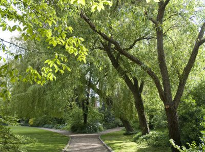
Ladbroke Square Garden, spring 2014, photoBECKET
Ladbroke Square Garden, at 2.82 hectares, is by far the largest garden on the estate and one of the largest square gardens in London. Unlike almost all the other communal gardens on the Ladbroke estate, there are houses backing onto it only on its north side; the other sides are bounded by roads – Ladbroke Grove, Ladbroke Grove and Kensington Park Road. It is enclosed on the north side by the tall stucco mansions along Kensington Park Gardens (Nos. 1-23 consec). Half-way along the road there is a gaop between the houses with an entrance with the entrance to the Garden and a pair of mid-19th century cast-iron gates (listed grade II) with the coat of arms of Felix Ladbroke on shields in the centre of inscribed circles).
The layout of the Ladbroke Square Garden was indicated in the original early 19th century design by Thomas Allason for the Ladbroke estate, although the Garden and the houses round it did not come into existence until the 1840s. An 1846 deed relating to No. 42 Ladbroke Square throws some light on the very early history of Ladbroke Square Garden. It mentions that on 27 April 1846, James Weller Ladbroke (the then owner of the Ladbroke estate) signed an agreement with Martin Stutely Esq., of Regent’s Park, whereby Stuteley covenanted to give access to the garden to the occupants of the houses then being built on the southern and eastern sides of the garden.
Stuteley was an architect who had originally worked with Jacob Connop, one of the big developers on the Ladbroke estate in the early 1840s. The plans for Connop’s holdings included three large squares, including Ladbroke Square. Like so many others involved in the Ladbroke estate, he ran into financial difficulties and was made bankrupt in 1845, before any progress had apparently been made on Ladbroke Square Garden. James Weller Ladbroke then redistributed the land that had previously been allocated to Connop, and gave leases of some 58 acres of the land to Stutely, including the future Ladbroke Square Garden, but made him covenant that he would give access for “exercise and recreation” to the present and future householders of the houses bordering the garden, together with “their respective families and lodgers”, as soon as the garden was “planted, made and enclosed”.
The householders were required to pay to Stutely and his successors an appropriate share of the costs of maintain the garden, set initially at three guineas (£3.3s), and to conform to such rules and regulations as should be agreed upon between Stutely and the current occupants of the houses.
James Weller Ladbroke died in 1847 and was succeeded by a cousin, Felix Ladbroke. Within two weeks of inheriting, he had sold the freehold of several of the houses along the south side of the Square and seems to have been keen to dispose of the Garden as well. To do so, in 1864 he set up a Trust Deed by which the freehold of the Garden was put in the names of trustees. The money to buy the Garden was raised by selling 100 shares to owners of houses within 100 yards of the Garden railings. The heirs of these people (where they can be traced) still have the right to vote at Annual General Meetings of the Garden Committee. The trust requires the Garden to be used as a pleasure ground or garden and set arrangements for the establishment of a garden committee for managing the garden. Unlike most of the other communal gardens, membership is open not just to the residents of houses backing onto the gardens, but also to residents of properties within 100 yards of the Garden.
The garden slopes from north to south, and retains its original path layout , including a broad walk running from west to east along the south side; a circular flower bed (originally a round pond which no doubt gave its name to Pond Field, which seems to have the field on which Ladbroke Square was created) surrounded by ornamental cast-iron urns on piers; a wooden summerhouse (one of a pair, the other demolished in the 1980s); and a gardener’s cottage in the north-east corner. The paths cross the garden to form three large lawns, backed by shrubberies, with a tennis court near the south-east corner. The mid-19th century planting includes planes, limes, beech, evergreen and semi-evergreen oaks, hawthorns, and horse chestnuts, which is supplemented by more recent planting of trees and flowers.
There is an interesting article in the Ladbroke Association newsletter of Spring 1987 about Ladbroke Square in the 1920s.
In respect of the houses backing onto the Garden, Nos. 1-22 Kensington Park Gardens are Grade II listed. There are also Article 4 Directions removing permitted development rights in respect of:
- alterations to the rear of house for Nos. 1-9 (consec.) Kensington Park Gardens.
- alterations to walls, gates and fences facing the communal gardens for Nos. 1-9 (consec) and the Cottage and entrance to Ladbroke Square Gardens between Nos. 9 and 10.
Contact: Mrs Knight 07717 477173 or info@ladbrokesquaregarden.com.
Lansdowne Road and Clarendon Road Garden (13)
This 0.41 hectare communal garden lies between Nos.26-42 (evens) Clarendon Road on its west side and 9-27 (odds) Lansdowne Road on its east side. It abuts Lansdowne Walk to the south and St John’s Gardens to the north. It is one of the earliest gardens in the estate. The garden slopes gently to the west and has a central shrub bed, connected to the perimeter path by a cross path which runs west/east (the mid-19thcentury north/south cross path has now gone). The communal garden is backed to the west and east by large private gardens, with replicas of the original street railings, including a curved cast-iron coping. The rest of the garden is open with scattered mature trees, including exceptionally fine planes and hawthorns.
The garden is constituted as a freehold in trust under a conveyance of 1928. There are three trustees appointed from among the residents..
There are Article 4 Directions removing permitted development rights in respect of:
- alterations to the rear of the house for all the Clarendon Road houses on the garden and for Nos. 15-27 Lansdowne Road.
- alterations to walls, gates and fences facing the communal gardens for all the Clarendon Road houses on the garden and for Nos. 9 and 15-27 Lansdowne Road.
There was an article on this garden in our Winter 1992 newsletter.
Contact: jonathan.stead@rapieruk.com
Lansdowne Crescent Garden (9)
The 0.3 hectare Lansdowne Crescent Garden is situated on the crest of the hill, bounded along the curving west side by the semi-detached villas along Lansdowne Crescent (Nos. 2-18 (consec.) and 63 Ladbroke Grove and their private gardens. The vicarage to St John’s church is situated in the southern corner of the garden. To the east, the garden is bounded by a tall terrace of houses (Nos. 65-77 odds) along Ladbroke Grove, which was originally terminated at each end by houses with large private gardens, now replaced by 20th century blocks of flats. There are no private gardens along the east side which has a raised terrace. The original path layout has been simplified and an additional path has been added across the centre of the garden. Most of the garden is open but there are roses trained on poles and pergolas. There is a street entrance from Ladbroke Grove.
The committee of this garden both sets and organises the collection of the charges for the upkeep of the garden, which are payable per freehold house, and there is no Council involvement.
There are Article 4 Directions removing permitted development rights in respect of:
- alterations to the rear of the house for Nos. 67-75 (odds) Ladbroke Grove.
Lansdowne Gardens (5)
Previously known as Lansdowne Road and Lansdowne Crescent Garden, it is a curving, triangular-shaped garden on a steep slope, extending over 0.48 hectares (1.2 acres). The garden is backed by terraced houses on two sides, Nos. 19-40 Lansdowne Crescent to the south and 46-108 (evens) Lansdowne Road to the north. No 81 Ladbroke Grove also abuts onto the garden. Part of the original path layout survives with some mature ash trees, supplemented by late 20th century trees and shrubs and with a playground inserted. The garden is protected under the Town Gardens Protection Act 1863.
Nos. 19-38 Lansdowne Crescent are Grade II listed. There are Article 4 Directions in respect of:
-
alterations to the rear of the house for 68-106 evens Lansdowne Road.
Contact: lansdownegardencommittee@gmail.com
Montpelier Garden (4)
One side of this communal garden abuts onto Lansdowne Rise and its name derives from the old name of Lansdowne Rise, which used to be Montpelier Road. It extends over 0.66 of a hectare, slopes to the west, and is largely open with fine mature trees. The garden curves between Lansdowne Road (Nos. 45-77 odds) to the east and the terraced houses along Clarendon Road (Nos. 60-78 evens) and Elgin Crescent (Nos. 117-151 odds) to the west and north-west. Nos. 1 and 2 Rosmead Road also adjoin the garden. The mid-19th century meandering perimeter path survives but the central path has been lost. The scattered mature trees on the lawn include ash, poplar, horse chestnut, a weeping willow, and a liquidamber. Iron gates were installed for the 1977 Jubilee.
The garden is constituted under the Town Gardens Protection Act 1863. There are Article 4 Directions removing permitted development rights in respect of:
- alterations to the rear of the house in respect of 49-77 Lansdowne Road; 68-78 (evens) Clarendon Road; and 125-151 Elgin Crescent
- alterations to walls, gates and fences facing the communal gardens for 45-77 Lansdowne Road; all the Clarendon Road houses; 125-151 Elgin Crescent; and 1 Rosmead Road.
Contact: Ms Adie, Treasurer contact
Notting Hill Garden (8)
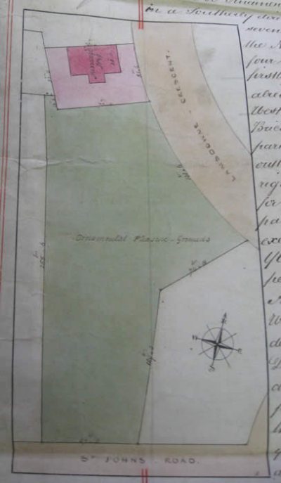
Plan of Notting Hill Garden from 1846 lease.
This small 0.2 hectare triangular communal garden lies on the hill near St John’s church. It is bounded to the west by Nos. 32-44 (evens) Lansdowne Road; to the north and north-east by Lansdowne Crescent (Nos. 43 and 44 adjoin the garden, but there is also a stretch between them with no buildings, giving a good view from the garden of the houses on the other side of Lansdowne Crescent); and by St John’s Gardens (Nos. 1 and 2) to the south-east. The original path layout survives. There are a number of scattered trees, including a fine horse chestnut and a taxodium. The street entrance is from St John’s Gardens. The garden is constituted under the Town Gardens Protection Act 1863.
The garden was created in the 1840s when Lansdowne Crescent was being built. There is a document dated 1 June 1846 in the Kensington Public Library by which the then owner of the Ladbroke estate, James Weller Ladbroke, gave a 94-year lease of the garden, together with a newly built house in Lansdowne Crescent, to the developer Richard Roy, who had no doubt financed the construction and the laying out of the garden (Deed No. 4604). Roy was required to enclose the pleasure ground with brick walls or iron railings on a stone kerb and to keep the garden properly planted or stocked. Roy and Ladbroke probably later disposed of both leasehold and freehold to trustees drawn from the residents of the new houses around the garden.
There are no article 4 Directions applying to the backs of the houses or to the walls and fences.
Chairman: Dr Gerald de Lacey, Notting Hill Garden W11 contact
Rosmead Garden (2)
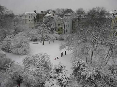
This used to be called the Lansdowne and Elgin Crescent Garden. It lies behind the houses along the south side of Elgin Crescent, and those on the north side of Lansdowne Road (between Rosmead Road and Ladbroke Grove). It extends over 0.82ha, and is a large, curving garden near the foot of the hill. It lies between the painted stucco houses along the south side of Elgin Crescent (Nos. 65-115 odds) to the north and Lansdowne Road (Nos. 79-123) to the south. The houses have their own private gardens giving onto the communal garden. The ends of the communal garden abut onto Ladbroke Grove to the east and onto Rosmead Road to the west.
The garden retains most of its mid C19 paths, although simplified in the centre, and its original railings with cast-iron coping along Rosmead Road. Shrubberies back three large oval-shaped lawns and there are dense evergreen shrubberies at the west and east ends. Osbert Lancaster (1908-86) lived in Elgin Crescent as a child and described it in All done from Memory (1963) and the Ladbroke Estate in general in The Pleasure Garden (1977), co-authored with Anne Scott-James. It is the garden in which Hugh Grant proposed to Julia Roberts in the film Notting Hill.
The garden is constituted under the Town Gardens Protection Act 1863. There are Article 4 Directions removing permitted development rights in respect of:
alterations to the rear of the house for 63-115 (odds) Elgin Crescent; and 79-103 and 113-119 (odds) Lansdowne Road
Read about Rosmead Garden Rules
Stanley Crescent Garden (10)
This 0.68 hectare (1.68) acre communal garden is bordered on its west side by the private gardens and semi-detached villas along Ladbroke Grove Nos. 36-68 evens). The curving east side is enclosed by the large houses along Stanley Crescent. It retains its early Victorian paths, internal railings and character. Three large open lawns are bordered by shrubberies and trees, separated by gravel paths. Large shrubberies with evergreens fill the triangles formed by paths and there are many large 19th century trees, including narrow-leaved ash, horse chestnuts, beech, lime, and plane trees. There are private gardens along the west side, which is lined by a broad gravel path terminating at gated entrances onto Ladbroke Gardens to the north and Kensington Park Gardens to the south. The private gardens along Stanley Crescent are smaller or non existent. A large mid C19 urn stands at the centre of the garden.
Constituted under the 1851 Kensington Improvement Act. 1-9 (consec.) Stanley Crescent and 36-40 (evens) Ladbroke Grove are Grade II listed. There are Article 4 Directions removing permitted development rights in respect of:
- alterations to the rear of the house for 46-68 Ladbroke Grove and 14-23 Stanley Crescent.
Contact: stanleycrescentgardens@gmail.com
Its website is: https://stanleycrescentgarden.wordpress.com/
See: http://stanleycrescentgarden.wordpress.com/rules/bye-laws/ for bye-laws
Stanley Gardens North (11)
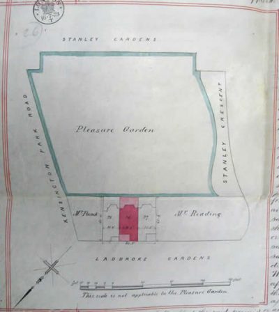
Plan of Stanley Gardens North in 1873 from a lease of 26 Ladbroke Gardens. It seems that the freeholder at the time was Charles Blake and householders paid a garden charge of two guineas.
This 0.36 hectare communal garden lies between the terraced stucco houses along Stanley Gardens to the south and the terrace along Ladbroke Gardens to the north. The garden was designed without private gardens and has a broad terraced path along the south side. The mid-19th century path layout survives around the perimeter, although a central cross path has been lost. There are fine trees including hawthorns, limes, and a weeping wych elm in the centre, and these trees have been supplemented by late 20th century planting of flowering trees including a magnolia.
Constituted under the 1851 Kensington Improvement Act. All the houses along the Stanley Gardens side are Grade II listed. There are Article 4 Directions removing permitted development rights in respect of:
- alterations to the rear of the house for Nos. 25-31 (consec.) Ladbroke Gardens.
Contact: stanleygardensnorth@gmail.com
Stanley Gardens South (12)
This one and a half acre (0.61 hectare) trapeziform communal garden is backed by the tall mansions along Kensington Park Gardens to the south, with a break in the centre and a gated entrance (directly opposite a gated entrance to Ladbroke Square Garden on the other side of Kensington Park Gardens). The stucco houses with their bow fronts along Stanley Gardens form the boundary to the north and north-east. The garden was designed without private back gardens and retains its original path layout, internal and street railings, and many 19th century trees. The mid-19th century circular bed has been converted into a children’s playground and the 19th century planting has been continued with 20th century trees and flowering plants.
Constituted under the 1851 Kensington Improvement Act. All the houses surrounding the garden are Grade II listed.
Contact: Anne Chorley, 19 Stanley Gardens, W11 2NG
Page last updated January 2024.
